Google today announced a major update for Google Maps on both Android and iOS, introducing new transit-related features.
Google Maps will now provide details on live traffic delays for buses in places where real-time information doesn't exist from local transit agencies, which will let Maps users see if a bus will be late, how long the delay might be, and how long travel might take.
Me during my commute: MOVE. THAT. BUS. Now you can see real-time delays and how crowded your bus is on your way to work 🙌 Read more here: https://t.co/mMrQY3ji5u pic.twitter.com/UwpyqCdYt9 — Google Maps (@googlemaps) June 27, 2019
The app will provide details on exactly where delays are on the map so riders will know what to expect before getting on a bus.
Along with live traffic information for buses, Google is adding crowdedness predictions for transit routes. Based on past ride information, Google Maps will offer up details on how crowded a bus, train, or subway is likely to be.
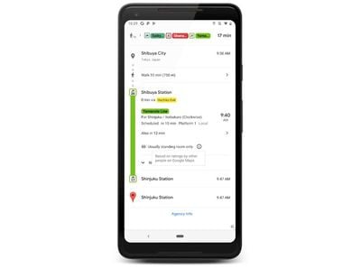
The new Google Maps features are rolling out today on Android and iOS in close to 200 cities around the world.


Top Rated Comments
The ‘crowdedness’ sounds awesome because sometimes busses are so full that you’ll have to stand.
I assume it’ll work the same way as how google shows how busy a shop is at certain times.
Where is the option to tell maps how large your vehicle is? Weight, length, height, etc, to prevent using roads that are inappropriate? Eg, clearance height, allowable weight on bridges, turning radius, and other common restrictions?
Glad to see these new features getting rolled out but would be great to cover the basics first no?